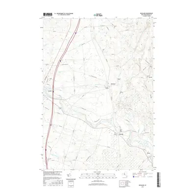
2016 Map of Richland
USGS Topo · Published 2016About this map
The Salmon River cuts a wide path through this portion of Oswego County, connecting a string of rural settlements including Pulaski, Richland, Pineville, and Altmar. This 2016 survey illustrates the persistent agricultural and riparian character of the landscape, where long-established family names are preserved in features like McClelland Cem and Stevens Cem. The transition from the more developed western corridor near Pulaski to the higher elevations of Gilbert Hill in the east is marked by a network of local routes such as Centerville Rd and Co Rte 2. Numerous small waterways, including Trout Brook and Orwell Cr, drain into the river valley, creating a complex hydrologic map. The concentration of historical burial sites, from Richland Village Cem to the Potter Cem, provides significant geographic markers for genealogical research in these small New York townships.
Find a feature on this map
77 named features on this map. Tap any name to fly to it.
Don’t see what you’re looking for? This feature index may not catch every label — zoom into the map to look around manually.
Map Details
Editions of this 2016 Richland Map
This is the sole edition of this map. No revisions or reprints were ever made.
Other maps of this area

1895 · Pulaski
USGS Topo · 1:62,500

1903 · Orwell
USGS Topo · 1:62,500

1905 · Orwell
USGS Topo · 1:62,500

1905 · Mexico
USGS Topo · 1:62,500

1906 · Kasoag
USGS Topo · 1:62,500

1942 · Sandy Creek
USGS Topo · 1:24,000

1943 · Pulaski
USGS Topo · 1:31,680
1943 · Boylston
USGS Topo · 1:31,680

1943 · Richland
USGS Topo · 1:31,680

1943 · Mexico
USGS Topo · 1:31,680