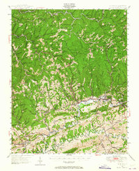
1947 Map of Richlands
USGS Topo · Published 1965About this map
Keen Mountain and the high ridges of the Clinch Valley dominate this postwar survey of the coal and rail corridor near the Buchanan, Tazewell, and Russell County borders. The industrial activity of the era is evident in the dense network of the Norfolk and Western railway lines serving coal settlements like Seaboard, Red Ash, and Jewell Valley. These communities supported a high density of local institutions, including the Baldwin Hg Seaboard School, Jewell Valley School, and numerous country churches such as Antioch Church.
Find a feature on this map
154 named features on this map. Tap any name to fly to it.
Don’t see what you’re looking for? This feature index may not catch every label — zoom into the map to look around manually.
Map Details
Editions of this 1947 Richlands Map
This is the sole edition of this map. No revisions or reprints were ever made.
Other maps of this area

1891 · Tazewell
USGS Topo · 1:125,000

1891 · Abingdon
USGS Topo · 1:125,000

1894 · Abingdon
USGS Topo · 1:125,000

1895 · Tazewell
USGS Topo · 1:125,000

1897 · Tazewell
USGS Topo · 1:125,000

1909 · Abingdon
USGS Topo · 1:96,000

1911 · Abingdon
USGS Topo · 1:125,000

1912 · Pounding Mill
USGS Topo · 1:62,500

1915 · Richlands
USGS Topo · 1:48,000

1916 · Pounding Mill
USGS Topo · 1:62,500