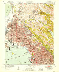
1947 Map of Richmond
USGS Topo · Published 1952About this map
Industrial and residential development along the East Bay shoreline is documented in this post-war survey, centered on the growing city of Richmond. The landscape is defined by the heavy infrastructure of the Oil Tank Farm and the maritime hubs at the Inner Harbor Basin and Harbor Channel, contrasting with the steep terrain of the Berkeley Hills to the east. Transportation networks are dominated by the Southern Pacific and Atchison Topeka and Santa Fe railroads, which weave through the flatlands to serve the waterfront.
Find a feature on this map
91 named features on this map. Tap any name to fly to it.
Don’t see what you’re looking for? This feature index may not catch every label — zoom into the map to look around manually.
Map Details
Editions of this 1947 Richmond Map
2 editions found
Other maps of this area

1895 · San Francisco
USGS Topo · 1:62,500

1896 · Carquinez Strait
USGS Topo · 1:62,500

1897 · Concord
USGS Topo · 1:62,500

1898 · Karquines
USGS Topo · 1:62,500

1899 · San Francisco
USGS Topo · 1:62,500

1901 · Karquines
USGS Topo · 1:62,500

1902 · Napa
USGS Topo · 1:125,000

1915 · Concord
USGS Topo · 1:62,500

1915 · San Francisco
USGS Topo · 1:62,500

1916 · Mare Island
USGS Topo · 1:62,500