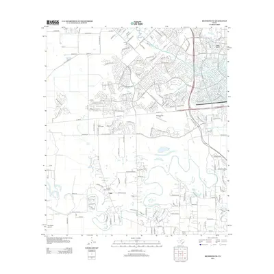
2013 Map of Richmond NE
USGS Topo · Published 2013About this map
Buffalo Bayou and Little Prong wind through a landscape of rapid suburban expansion and established agricultural legacy in this 2013 survey. The master-planned community of Cinco Ranch dominates the northeastern corner, characterized by winding residential streets and water features, while the western portion maintains more rural roots. Nearby, the Fulshear Oil Field points to the region's industrial foundations alongside the small settlements of Foster and Oak Hill. Aviation is a notable theme across the area, with several private airfields including Westheimer Air Park, Covey Trails Airport, and Heritage Ranch Airport serving the local community. Genealogists and local historians can locate family landmarks such as Briscoe Cem and Goss Cem, as well as the topographical landmark of Huntington Mound near the southern edge of the quadrangle.
Find a feature on this map
163 named features on this map. Tap any name to fly to it.
Don’t see what you’re looking for? This feature index may not catch every label — zoom into the map to look around manually.
Map Details
Editions of this 2013 Richmond NE Map
This is the sole edition of this map. No revisions or reprints were ever made.
Other maps of this area

1915 · Katy
USGS Topo · 1:24,000

1915 · Addicks
USGS Topo · 1:24,000

1915 · Clodine
USGS Topo · 1:24,000

1918 · Addicks
USGS Topo · 1:31,680

1919 · Clodine
USGS Topo · 1:31,680

1950 · Houston
USGS Topo · 1:250,000
1955 · Addicks
USGS Topo · 1:62,500

1955 · Sugar Land
USGS Topo · 1:62,500

1955 · Brookshire
USGS Topo · 1:62,500

1955 · Richmond
USGS Topo · 1:62,500