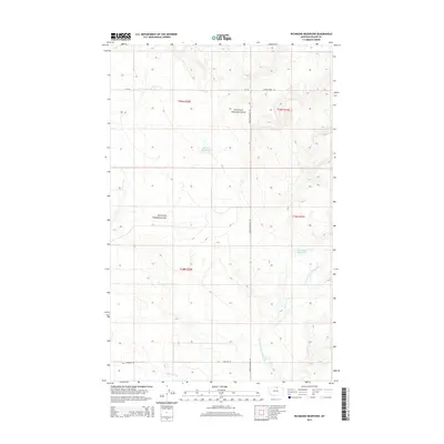
2014 Map of Richmond Reservoir
USGS Topo · Published 2014About this map
Richmond Reservoir and Harbolt Reservoir anchor the water management landscape of this Blaine County high-plains region, reflecting the essential role of water storage in Montana’s agricultural heartland. The terrain is defined by dramatic erosional features like the North Fork Chouteau Coulee, where seasonal drainages have carved deep impressions into the prairie. A grid of rural roads, including Zurich Canadian Rd and Cherigan Rd, provides the backbone for ranching access across the township boundaries of T35N and T36N. These paths follow the natural contours of the land, connecting remote grazing territories to the wider valley infrastructure. The drainage systems of Northwest Fork Thirtymile Cr and Fifteenmile Cr illustrate the complex watershed that supports the local ecology and livestock operations in this sparsely settled northern reach.
Find a feature on this map
13 named features on this map. Tap any name to fly to it.
Don’t see what you’re looking for? This feature index may not catch every label — zoom into the map to look around manually.
Map Details
Editions of this 2014 Richmond Reservoir Map
This is the sole edition of this map. No revisions or reprints were ever made.
Other maps of this area

1904 · Chinook
USGS Topo · 1:62,500

1905 · Harlem
USGS Topo · 1:62,500

1912 · Zurich
USGS Topo · 1:125,000

1913 · Cherry Ridge
USGS Topo · 1:125,000

1953 · Havre
USGS Topo · 1:250,000

1957 · Havre
USGS Topo · 1:250,000

1958 · Havre
USGS Topo · 1:250,000

1964 · Rabbit Hills
USGS Topo · 1:24,000

1984 · Richmond Reservoir
USGS Topo · 1:24,000
1984 · Richmond Reservoir SW
USGS Topo · 1:24,000