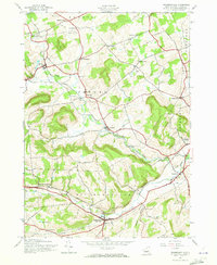
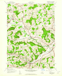
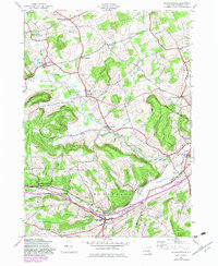
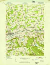
1944 Map of Richmondville
USGS Topo · Published 1973About this map
Richmondville and the surrounding Schoharie County hillsides are defined by the narrow corridors of the Delaware and Hudson railroad and the winding Cobleskill Creek. During this mid-1940s field survey, the landscape was dotted with traditional rural infrastructure, including a numbered school system ranging from School No 14 in the northwest to School No 6 in the south. The concentration of settlements like Warnerville, Hyndsville, and Seward illustrates a well-connected network of small villages tied to the rail line and creek valleys.
Find a feature on this map
36 named features on this map. Tap any name to fly to it.
Don’t see what you’re looking for? This feature index may not catch every label — zoom into the map to look around manually.
Map Details
Editions of this 1944 Richmondville Map
4 editions found

Other maps of this area

1896 · Fonda
USGS Topo · 1:62,500

1898 · Fonda
USGS Topo · 1:62,500

1898 · Canajoharie
USGS Topo · 1:62,500

1898 · Schoharie
USGS Topo · 1:62,500

1900 · Canajoharie
USGS Topo · 1:62,500

1900 · Schoharie
USGS Topo · 1:62,500

1902 · Canajoharie
USGS Topo · 1:62,500

1902 · Fonda
USGS Topo · 1:62,500

1904 · Richmondville
USGS Topo · 1:62,500
1943 · Cobleskill
USGS Topo · 1:24,000