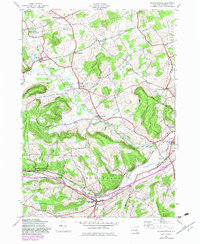
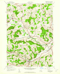
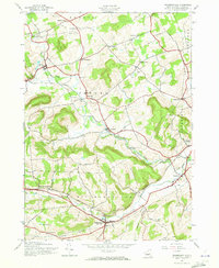
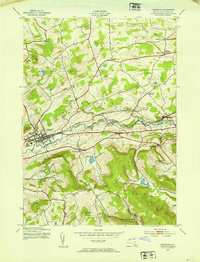
1944 Map of Richmondville
USGS Topo · Published 1983About this map
The Delaware and Hudson railroad corridor anchors the southern valley of this Schoharie County landscape, following the winding path of Cobleskill Creek and Schenevus Creek. This survey, based on 1940s aerial photography with 1980s revisions, illustrates a network of small upland settlements and crossroads including Richmondville, Hyndsville, and Lawyersville. The map is particularly detailed regarding rural infrastructure, documenting numerous district schools such as School No 14 and School No 6, alongside family and community burial grounds like Beekman Cem and Clock Cem.
Find a feature on this map
36 named features on this map. Tap any name to fly to it.
Don’t see what you’re looking for? This feature index may not catch every label — zoom into the map to look around manually.
Map Details
Editions of this 1944 Richmondville Map
4 editions found

Other maps of this area

1896 · Fonda
USGS Topo · 1:62,500

1898 · Fonda
USGS Topo · 1:62,500

1898 · Canajoharie
USGS Topo · 1:62,500

1898 · Schoharie
USGS Topo · 1:62,500

1900 · Canajoharie
USGS Topo · 1:62,500

1900 · Schoharie
USGS Topo · 1:62,500

1902 · Canajoharie
USGS Topo · 1:62,500

1902 · Fonda
USGS Topo · 1:62,500

1904 · Richmondville
USGS Topo · 1:62,500
1943 · Cobleskill
USGS Topo · 1:24,000