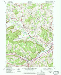
1944 Map of Richmondville
USGS Topo · Published 1994About this map
Richmondville and Cobleskill anchor this rural landscape in Schoharie County, which transitioned through the mid-20th century as new transportation corridors like Interchange 21 and Interchange 20 were introduced. The map reveals a settlement pattern dictated by the winding paths of Schenevus Creek, Cobleskill Creek, and West Creek. A distinct Railroad Grade cuts through the territory of Seward, passing the quiet hamlets of Hyndsville and Janesville. Local history is deeply etched into the topography, with family and community landmarks such as Peoples Cem, Strobeck Cem, and St Johns Ch scattered across the uplands of Pine Hill. The inclusion of a Shale Pit and the local Waterworks provides a clear view of the area's essential infrastructure during this era.
Find a feature on this map
36 named features on this map. Tap any name to fly to it.
Don’t see what you’re looking for? This feature index may not catch every label — zoom into the map to look around manually.
Map Details
Editions of this 1944 Richmondville Map
4 editions found
Other maps of this area

1896 · Fonda
USGS Topo · 1:62,500

1898 · Fonda
USGS Topo · 1:62,500

1898 · Canajoharie
USGS Topo · 1:62,500

1898 · Schoharie
USGS Topo · 1:62,500

1900 · Canajoharie
USGS Topo · 1:62,500

1900 · Schoharie
USGS Topo · 1:62,500

1902 · Canajoharie
USGS Topo · 1:62,500

1902 · Fonda
USGS Topo · 1:62,500

1904 · Richmondville
USGS Topo · 1:62,500

1943 · Cobleskill
USGS Topo · 1:24,000