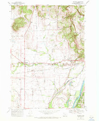
1969 Map of Rickreall
USGS Topo · Published 1971About this map
Rickreall and its surrounding agricultural landscape are defined by the convergence of several transportation networks and the wetlands of the Baskett Slough National Wildlife Refuge. Situated in the heart of Polk County, the area shows a transition from the rolling hills of Holmes Hill and Bald Hill down toward the winding Willamette River. The Southern Pacific railroad remains a dominant feature, threading through several small rural junctions including Derry, Gerlinger, and Thielson. Local life is anchored by family-named landmarks like Brunks Corner and Orrs Corner, alongside essential community sites such as the Greenwood Sch and the Fairgrounds in Rickreall. The map captures the complex drainage of the valley, with numerous waterways like Mud Slough and Rickreall Creek feeding the fertile landscape between the river and the refuge hills.
Find a feature on this map
48 named features on this map. Tap any name to fly to it.
Don’t see what you’re looking for? This feature index may not catch every label — zoom into the map to look around manually.
Map Details
Editions of this 1969 Rickreall Map
2 editions found
Other maps of this area

1914 · Independence
USGS Topo · 1:31,680

1915 · Rickreall
USGS Topo · 1:31,680

1915 · Eola
USGS Topo · 1:31,680

1915 · Sidney
USGS Topo · 1:31,680

1917 · Salem
USGS Topo · 1:62,500

1922 · Airlie
USGS Topo · 1:31,680

1924 · Mc Minnville
USGS Topo · 1:48,000

1926 · Mc Minnville
USGS Topo · 1:62,500

1940 · McMinnville
USGS Topo · 1:62,500

1940 · Salem
USGS Topo · 1:62,500