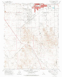
1973 Map of Ridgecrest South
USGS Topo · Published 1975About this map
Ridgecrest serves as a developing desert hub in this early 1970s survey, marked by the intersection of China Lake Boulevard and Ridgecrest Boulevard. The town's infrastructure is clearly visible, featuring civic landmarks like the City Hall, Post Office, and Courthouse, alongside educational centers such as Monroe Sch and St Ann Sch. To the south, the academic presence of Cerro Coso Jr College sits on the edge of more rugged terrain where the Indian Wells Valley meets the mountainous landscape.
Find a feature on this map
29 named features on this map. Tap any name to fly to it.
Don’t see what you’re looking for? This feature index may not catch every label — zoom into the map to look around manually.
Map Details
Editions of this 1973 Ridgecrest South Map
This is the sole edition of this map. No revisions or reprints were ever made.
Other maps of this area

1903 · Randsburg
USGS Topo · 1:62,500

1911 · Randsburg
USGS Topo · 1:62,500

1912 · Randsburg
USGS Topo · 1:62,500

1915 · Searles Lake
USGS Topo · 1:250,000

1943 · Inyokern
USGS Topo · 1:62,500

1943 · Saltdale
USGS Topo · 1:62,500

1947 · Trona
USGS Topo · 1:250,000

1948 · Trona
USGS Topo · 1:250,000

1953 · Ridgecrest
USGS Topo · 1:62,500

1953 · Trona
USGS Topo · 1:250,000