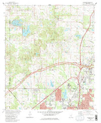
1980 Map of Ridgeland
USGS Topo · Published 1986About this map
Tougaloo College serves as a historic anchor on this landscape, situated near the Illinois Central Gulf Railroad line and the Tougaloo settlement. The map reveals a suburban transition at the northern edge of Jackson, where modern residential streets like Winterview Drive and Adkins Blvd meet a network of rural churches and private lakes. The Natchez Trace Parkway cuts diagonally across the terrain, passing through a region dotted with water bodies such as Lake Lorman, Lake Cavalier, and Costas Lake. Local history is preserved through numerous rural congregations, including Mt Olive Ch and China Grove Ch, while the presence of a Lookout Tower and a Fish Hatchery points to mid-century land management practices. The landscape is also marked by resource extraction, with multiple Sandpit and Gravel Pits locations visible near Ridgeland.
Find a feature on this map
48 named features on this map. Tap any name to fly to it.
Don’t see what you’re looking for? This feature index may not catch every label — zoom into the map to look around manually.
Map Details
Editions of this 1980 Ridgeland Map
3 editions found
Other maps of this area

1903 · Jackson
USGS Topo · 1:125,000

1905 · Jackson
USGS Topo · 1:48,000

1908 · Jackson
USGS Topo · 1:62,500

1934 · Raymond
USGS Topo · 1:48,000

1937 · Raymond
USGS Topo · 1:62,500

1942 · Raymond
USGS Topo · 1:62,500

1955 · Jackson
USGS Topo · 1:250,000

1961 · Jackson
USGS Topo · 1:250,000

1961 · Canton
USGS Topo · 1:62,500

1962 · Jackson
USGS Topo · 1:250,000