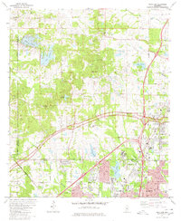
1980 Map of Ridgeland
USGS Topo · Published 1980About this map
Tougaloo College and the surrounding community of Tougaloo serve as a focal point on this 1980 survey of the Mississippi landscape north of Jackson. The area is defined by a series of significant water bodies, including Lake Lorman, Lake Cavalier, and Lake Roanna, which illustrate the region's managed water resources. Religious and educational institutions are densely scattered throughout, from China Grove Ch in the north to the Jackson College of Ministries near Hanging Moss Creek.
Find a feature on this map
53 named features on this map. Tap any name to fly to it.
Don’t see what you’re looking for? This feature index may not catch every label — zoom into the map to look around manually.
Map Details
Editions of this 1980 Ridgeland Map
3 editions found
Other maps of this area

1903 · Jackson
USGS Topo · 1:125,000

1905 · Jackson
USGS Topo · 1:48,000

1908 · Jackson
USGS Topo · 1:62,500

1934 · Raymond
USGS Topo · 1:48,000

1937 · Raymond
USGS Topo · 1:62,500

1942 · Raymond
USGS Topo · 1:62,500

1955 · Jackson
USGS Topo · 1:250,000

1961 · Jackson
USGS Topo · 1:250,000

1961 · Canton
USGS Topo · 1:62,500

1962 · Jackson
USGS Topo · 1:250,000