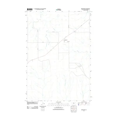
2012 Map of Ridgeview
USGS Topo · Published 2012About this map
Ridgeview serves as the primary focal point of this Dewey County landscape, situated where the high plains are carved by a complex drainage system. The settlement is centered near Saint Josephs Cem, anchoring a community defined by vast agricultural tracts and ranching operations like the Hiett Ranch. This 2012 survey illustrates the essential relationship between the land and the water that sustains it, as several significant seasonal streams traverse the area. Cottonwood Cr and Virgin Cr meander through the northern and central sections, while the southern reaches are defined by the uniquely named W Br Tall Prairie Chicken Cr and E Br Tall Prairie Chicken Cr. The map captures the connectivity of this rural region, with local routes such as Co HWY-15c and Co HWY-15 providing the framework for movement between isolated homesteads and the town center.
Find a feature on this map
14 named features on this map. Tap any name to fly to it.
Don’t see what you’re looking for? This feature index may not catch every label — zoom into the map to look around manually.
Map Details
Editions of this 2012 Ridgeview Map
This is the sole edition of this map. No revisions or reprints were ever made.
Other maps of this area

1951 · Ridgeview NW
USGS Topo · 1:24,000

1951 · Ridgeview NE
USGS Topo · 1:24,000

1951 · La Plant
USGS Topo · 1:24,000

1953 · McIntosh
USGS Topo · 1:250,000

1954 · Pierre
USGS Topo · 1:250,000

1958 · Pierre
USGS Topo · 1:250,000

1958 · McIntosh
USGS Topo · 1:250,000

1981 · Charlie Creek
USGS Topo · 1:24,000

1981 · Rousseau Creek NW
USGS Topo · 1:24,000
1981 · No Heart Creek
USGS Topo · 1:24,000