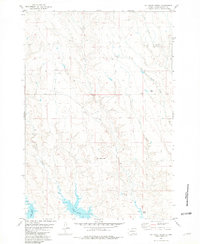
1981 Map of No Heart Creek
USGS Topo · Published 1981About this map
Lake Oahe and its rising waters dominate the southern landscape of this 1980s survey, illustrating the controlled inundation of the Missouri River valley within the Cheyenne River Indian Reservation. The drainage of No Heart Creek snakes through the center of the sheet, leading toward the prominent elevation of No Heart Butte. This era in Dewey County history is characterized by scattered ranching outposts, including the Fast Horse Ranch, Clark Ranch, and Means Ranch, which are connected by a network of unimproved roads and cattle trails. The map documents the shifting hydrology of the region, where seasonal flows like Little Willow Creek, Corral Creek, and Charlie Creek carve through the breaks and draws above the reservoir's shoreline. These landmarks, along with survey points such as Chicken BM 1976, provide a precise record of the land use and topography during a period of significant environmental transition in central South Dakota.
Find a feature on this map
14 named features on this map. Tap any name to fly to it.
Don’t see what you’re looking for? This feature index may not catch every label — zoom into the map to look around manually.
Map Details
Editions of this 1981 No Heart Creek Map
This is the sole edition of this map. No revisions or reprints were ever made.
Other maps of this area

1953 · McIntosh
USGS Topo · 1:250,000

1954 · Pierre
USGS Topo · 1:250,000

1958 · Pierre
USGS Topo · 1:250,000

1958 · McIntosh
USGS Topo · 1:250,000

1969 · Rousseau Creek
USGS Topo · 1:24,000

1969 · No Heart Creek SE
USGS Topo · 1:24,000

1969 · No Heart Creek SW
USGS Topo · 1:24,000

1981 · Charlie Creek
USGS Topo · 1:24,000
1981 · No Heart Creek NE
USGS Topo · 1:24,000
1981 · Stove Creek
USGS Topo · 1:24,000