
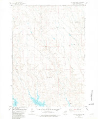
1969 Map of Rousseau Creek
USGS Topo · Published 1972About this map
Cheyenne River Indian Reservation land meets the rising waters of Lake Oahe in this study of central South Dakota. The landscape is defined by the confluence of the Cheyenne River and the Missouri River basin, showing the extensive shoreline of the reservoir as it fills the deep draws and creek beds. The map documents a specific moment of transition as the Department of the Interior managed the development of the Missouri River Basin, with large areas marked as subject to controlled inundation. Inland from the water, the terrain is cut by drainage features like Fine Weather Draw and the winding course of Rousseau Creek. Evidence of early settlement and land use remains visible through the placement of a lone Cem near the river bluffs and the numerous fence and field lines identified from aerial photography, tracing the agricultural footprint on the high ground above the reservoir.
Find a feature on this map
14 named features on this map. Tap any name to fly to it.
Don’t see what you’re looking for? This feature index may not catch every label — zoom into the map to look around manually.
Map Details
Editions of this 1969 Rousseau Creek Map
This is the sole edition of this map. No revisions or reprints were ever made.
Other maps of this area

1954 · Pierre
USGS Topo · 1:250,000

1956 · Rousseau Creek SW
USGS Topo · 1:24,000

1956 · Crockett Mountains
USGS Topo · 1:24,000

1958 · Pierre
USGS Topo · 1:250,000

1969 · No Heart Creek SW
USGS Topo · 1:24,000

1973 · Iron Post Buttes
USGS Topo · 1:24,000

1981 · Charlie Creek
USGS Topo · 1:24,000

1981 · Rousseau Creek NW
USGS Topo · 1:24,000
1981 · No Heart Creek
USGS Topo · 1:24,000

1982 · Mission Ridge
USGS Topo · 1:24,000