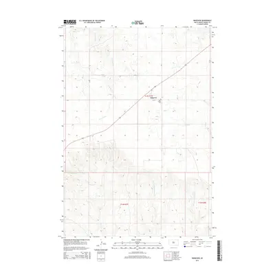
2015 Map of Ridgeview
USGS Topo · Published 2015About this map
Ridgeview serves as the central point of this high-plains landscape, situated along a straight highway corridor that cuts through the surrounding prairie. This 2015 survey highlights the rural character of Dewey County, where the settlement is anchored by Saint Josephs Cem just to the east. The land is defined by a dendritic network of drainages, most notably the evocatively named W Br Tall Prairie Chicken Cr and E Br Tall Prairie Chicken Cr in the southern portion of the quadrangle. These watercourses, along with Cottonwood Cr, Virgin Cr, and Charlie Cr, dictate the movement and layout of section roads such as CR-15 and Bia-3. The survey provides an essential view of the traditional township and range divisions, showing how early 21st-century infrastructure follows the established patterns of the Great Plains.
Find a feature on this map
16 named features on this map. Tap any name to fly to it.
Don’t see what you’re looking for? This feature index may not catch every label — zoom into the map to look around manually.
Map Details
Editions of this 2015 Ridgeview Map
This is the sole edition of this map. No revisions or reprints were ever made.
Other maps of this area

1951 · Ridgeview NW
USGS Topo · 1:24,000

1951 · Ridgeview NE
USGS Topo · 1:24,000

1951 · La Plant
USGS Topo · 1:24,000

1953 · McIntosh
USGS Topo · 1:250,000

1954 · Pierre
USGS Topo · 1:250,000

1958 · Pierre
USGS Topo · 1:250,000

1958 · McIntosh
USGS Topo · 1:250,000

1981 · Charlie Creek
USGS Topo · 1:24,000

1981 · Rousseau Creek NW
USGS Topo · 1:24,000
1981 · No Heart Creek
USGS Topo · 1:24,000