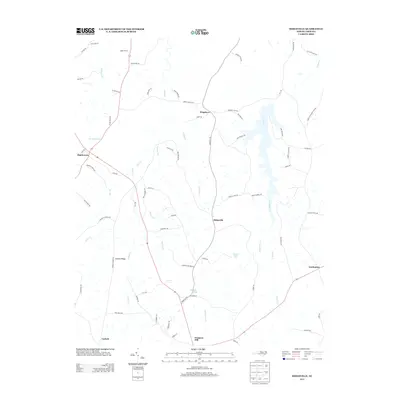
2013 Map of Ridgeville
USGS Topo · Published 2013About this map
Ridgeville serves as a central point in this rural landscape of Caswell County, where the Piedmont terrain is defined by a network of creeks and small family-named crossroads. The drainage patterns of Hyco Cr and S Hyco Cr dictate the layout of the local road system, which connects small communities like Frogsboro, Hightowers, and Gordonton. Many of these settlements are situated on higher ground, such as Corbett Ridge, avoiding the lower reaches of Panther Br and Coneys Cr. Several water features, including Morgans Pond and Carvers Lake, suggest localized agricultural or recreational impoundments. This 2013 survey illustrates a quiet, distributed settlement pattern where local roads like Pooletown Rd and Griers Church Rd link legacy properties and rural residences within the historic tobacco-growing region of North Carolina.
Find a feature on this map
72 named features on this map. Tap any name to fly to it.
Don’t see what you’re looking for? This feature index may not catch every label — zoom into the map to look around manually.
Map Details
Editions of this 2013 Ridgeville Map
This is the sole edition of this map. No revisions or reprints were ever made.
Other maps of this area

1953 · Greensboro
USGS Topo · 1:250,000

1954 · Greensboro
USGS Topo · 1:250,000

1962 · Greensboro
USGS Topo · 1:250,000

1966 · Greensboro
USGS Topo · 1:250,000

1967 · Cedar Grove
USGS Topo · 1:24,000

1968 · Leasburg
USGS Topo · 1:24,000

1968 · Caldwell
USGS Topo · 1:24,000

1968 · Ridgeville
USGS Topo · 1:24,000

1968 · Hurdle Mills
USGS Topo · 1:24,000
1968 · Olive Hill
USGS Topo · 1:24,000