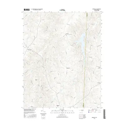
2016 Map of Ridgeville
USGS Topo · Published 2016About this map
The rolling Piedmont landscape of Caswell and Person Counties is defined by a dense network of country roads and small, historic crossroads communities in the mid-2010s. The central settlement of Ridgeville serves as a geographic anchor, situated near the headwaters of Sugartree Cr and Hyco Cr. To the north, the small hamlet of Frogsboro sits above the upper reaches of the river drainage, while the southern portion of the sheet features the high ground of Corbett Ridge and the community of Prospect Hill.
Find a feature on this map
74 named features on this map. Tap any name to fly to it.
Don’t see what you’re looking for? This feature index may not catch every label — zoom into the map to look around manually.
Map Details
Editions of this 2016 Ridgeville Map
This is the sole edition of this map. No revisions or reprints were ever made.
Other maps of this area

1953 · Greensboro
USGS Topo · 1:250,000

1954 · Greensboro
USGS Topo · 1:250,000

1962 · Greensboro
USGS Topo · 1:250,000

1966 · Greensboro
USGS Topo · 1:250,000

1967 · Cedar Grove
USGS Topo · 1:24,000

1968 · Leasburg
USGS Topo · 1:24,000

1968 · Caldwell
USGS Topo · 1:24,000

1968 · Ridgeville
USGS Topo · 1:24,000

1968 · Hurdle Mills
USGS Topo · 1:24,000
1968 · Olive Hill
USGS Topo · 1:24,000