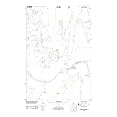
2011 Map of Riggins Hot Springs
USGS Topo · Published 2011About this map
Riggins Hot Springs serves as a focal point along the northern banks of the Salmon River, where the river cuts through a complex vertical landscape. In this 2011 survey, the area is defined by its recreation and isolated outposts, including Hinkley Cabin and Long Cabin positioned at the ends of forest routes. The winding Salmon River Rd follows the water's edge, connecting points like Music Bar and Crum to several public recreation areas. Higher elevations are marked by distinctive landmarks like Berg Mountain and Keating Ridge, with the drainage of Allison Creek and Warm Springs Creek creating deep incisions in the terrain. These waterways and canyons reflect a landscape where human presence is sparse, centered primarily on seasonal camps and the historical infrastructure of the Partridge Creek Bridge.
Find a feature on this map
42 named features on this map. Tap any name to fly to it.
Don’t see what you’re looking for? This feature index may not catch every label — zoom into the map to look around manually.
Map Details
Editions of this 2011 Riggins Hot Springs Map
This is the sole edition of this map. No revisions or reprints were ever made.
Other maps of this area

1938 · Riggins
USGS Topo · 1:96,000

1945 · Riggins
USGS Topo · 1:125,000

1955 · Grangeville
USGS Topo · 1:250,000

1959 · Grangeville
USGS Topo · 1:250,000

1963 · John Day Mtn
USGS Topo · 1:24,000

1963 · Lucile
USGS Topo · 1:24,000

1963 · Hershey Point
USGS Topo · 1:24,000
1963 · Florence
USGS Topo · 1:24,000
1964 · Patrick Butte
USGS Topo · 1:24,000

1964 · Riggins
USGS Topo · 1:24,000