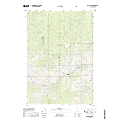
2020 Map of Riggins Hot Springs
USGS Topo · Published 2020About this map
Riggins Hot Springs is situated along the bends of the Salmon River within the Nez Perce National Forest, a landscape defined by significant elevation changes and remote river access points. The river's course is punctuated by features such as Ruby Rapids and riverbars like Music Bar and Spring Bar, which serve as key landmarks for those navigating the waterway. In the canyon depths and atop the surrounding heights, the map shows a network of National Forest Development Roads, including Natl Forest Develop Road 207 Rd and Natl Forest Develop Road 263 Rd, which provide access to ridges like Padrick Ridge and Keating Ridge. The topography is particularly striking at Box Canyon and Berg Mtn, illustrating the steep drainages of Allison Cr and Lake Cr as they feed into the main river system near the Partridge Creek Bridge.
Find a feature on this map
48 named features on this map. Tap any name to fly to it.
Don’t see what you’re looking for? This feature index may not catch every label — zoom into the map to look around manually.
Map Details
Editions of this 2020 Riggins Hot Springs Map
This is the sole edition of this map. No revisions or reprints were ever made.
Other maps of this area

1938 · Riggins
USGS Topo · 1:96,000

1945 · Riggins
USGS Topo · 1:125,000

1955 · Grangeville
USGS Topo · 1:250,000

1959 · Grangeville
USGS Topo · 1:250,000

1963 · John Day Mtn
USGS Topo · 1:24,000

1963 · Lucile
USGS Topo · 1:24,000

1963 · Hershey Point
USGS Topo · 1:24,000
1963 · Florence
USGS Topo · 1:24,000
1964 · Patrick Butte
USGS Topo · 1:24,000

1964 · Riggins
USGS Topo · 1:24,000