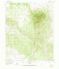
1959 Map of Riley
USGS Topo · Published 1967About this map
Riley stands as a focal point of this New Mexico landscape, situated where the high desert terrain meets the intermittent waters of the Rio Salado. Based on 1956 aerial photography and a 1959 field check, the survey documents a region defined by ranching and vast public lands, with the Cibola National Forest boundary cutting across the southwestern quadrant. The drainage patterns of Coyote Draw and Mariano Draw illustrate the arid geography of Socorro County, feeding into the wider river valley. Remote outposts like the Lazy C Bar J Ranch and isolated water sources such as Tortola Spring and Silver Creek provide essential markers for understanding the settlement and land-use history of this high-altitude basin before the expansion of modern infrastructure.
Find a feature on this map
9 named features on this map. Tap any name to fly to it.
Don’t see what you’re looking for? This feature index may not catch every label — zoom into the map to look around manually.
Map Details
Editions of this 1959 Riley Map
2 editions found

Other maps of this area

1906 · Socorro
USGS Topo · 1:62,500

1916 · La Joya
USGS Topo · 1:125,000

1917 · Cerro Verde
USGS Topo · 1:125,000

1952 · La Joya NW
USGS Topo · 1:24,000

1952 · San Anacia
USGS Topo · 1:24,000

1952 · Belen SW
USGS Topo · 1:24,000

1954 · Socorro
USGS Topo · 1:250,000

1956 · Mesa Aparejo
USGS Topo · 1:62,500

1958 · Socorro
USGS Topo · 1:250,000

1959 · Lemitar
USGS Topo · 1:24,000