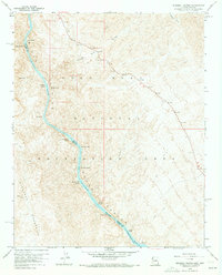
1959 Map of Ringbolt Rapids
USGS Topo · Published 1973About this map
Black Canyon serves as the dramatic centerpiece of this late 1950s survey, where the Colorado River carves a deep boundary between Arizona and Nevada. The river corridor is defined by a series of turbulent whitewater reaches, including Ringbolt Rapids, Cross Current Rapids, and Horseshoe Rapids. This section of the river, within the Lake Mead National Recreation Area, showcases the complex hydrology of the canyon prior to further regional development, marked by the presence of a Gaging Station and several remote Hot Springs. On the Arizona side, the landscape is dominated by steep drainages like White Rock Canyon and Horsethief Canyon, while the Nevada side is guarded by the high peaks of the Eldorado Mountains. The map also documents institutional footprints in this wild terrain, specifically the Ranger Station and a State Fish Hatchery located near the southern bend of the river.
Find a feature on this map
39 named features on this map. Tap any name to fly to it.
Don’t see what you’re looking for? This feature index may not catch every label — zoom into the map to look around manually.
Map Details
Editions of this 1959 Ringbolt Rapids Map
4 editions found
Other maps of this area

1886 · Camp Mohave
USGS Topo · 1:250,000

1886 · Saint Thomas
USGS Topo · 1:250,000

1892 · Camp Mohave
USGS Topo · 1:250,000

1893 · Saint Thomas
USGS Topo · 1:250,000

1926 · Nelson
USGS Topo · 1:96,000

1926 · Boulder Canyon
USGS Topo · 1:96,000

1942 · Camp Mohave
USGS Topo · 1:250,000

1947 · Kingman
USGS Topo · 1:250,000

1948 · Kingman
USGS Topo · 1:250,000

1952 · Henderson
USGS Topo · 1:62,500