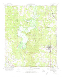
1972 Map of Ringgold
USGS Topo · Published 1974About this map
Lake Bistineau dominates this landscape along the borders of Bossier, Webster, and Bienville Parishes, featuring a complex network of islands such as Snake Island and Peggys Island. The map documents the region's mid-century energy and infrastructure, specifically the Bistineau Gas Field and the Sibley Oil and Gas Field. To the east, the town of Ringgold serves as a local hub, while the Kansas City Southern railroad cuts through the southwestern corner near Ninock. The area is densely marked with family and community landmarks, including the Theus Cem, Gilmer Cem, and Wimberly Cem. From the Fish Hatchery near the lake's edge to the Hail Summit Lookout Tower, the sheet provides a detailed view of North Louisiana's rural economy, timber lands, and recreational spaces like Lake Bistineau State Park.
Find a feature on this map
106 named features on this map. Tap any name to fly to it.
Don’t see what you’re looking for? This feature index may not catch every label — zoom into the map to look around manually.
Map Details
Editions of this 1972 Ringgold Map
This is the sole edition of this map. No revisions or reprints were ever made.
Other maps of this area

1932 · Bossier SE
USGS Topo · 1:31,680

1938 · Arnsberg
USGS Topo · 1:31,680

1941 · East Point
USGS Topo · 1:31,680

1941 · Bossier Point
USGS Topo · 1:31,680

1945 · Mansfield
USGS Topo · 1:62,500

1947 · Ringgold
USGS Topo · 1:62,500

1947 · Ashland
USGS Topo · 1:62,500

1947 · Mansfield
USGS Topo · 1:62,500

1947 · Minden
USGS Topo · 1:62,500

1948 · Coushatta
USGS Topo · 1:62,500