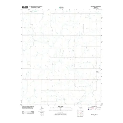
2009 Map of Ringling NW
USGS Topo · Published 2009About this map
Mud Creek and its many winding tributaries define the rural landscape of southern Oklahoma during the early 21st century. The terrain is characterized by a high density of small water bodies and drainage systems, including Negro Creek, Crooked Creek, and Post Oak Creek, which create a complex hydrological network. Near the northern border, the Oknoname 067007 Dam contains the Oknoname 067007 Reservoir, serving as a primary water management feature for the surrounding ranch or agricultural land. A grid-based road system, including E 1910 RD and N 2960 RD, provides access across the sectioned countryside. In the eastern portion of the map, transportation infrastructure expands with the presence of the Ringling Municipal Airport and named thoroughfares such as Rapier Blvd and Rose Blvd, indicating proximity to localized aviation and residential development.
Find a feature on this map
23 named features on this map. Tap any name to fly to it.
Don’t see what you’re looking for? This feature index may not catch every label — zoom into the map to look around manually.
Map Details
Editions of this 2009 Ringling NW Map
This is the sole edition of this map. No revisions or reprints were ever made.
Other maps of this area

1901 · Addington
USGS Topo · 1:125,000

1957 · Ardmore
USGS Topo · 1:250,000

1962 · Ryan
USGS Topo · 1:62,500

1963 · Ardmore
USGS Topo · 1:250,000

1964 · Comanche SE
USGS Topo · 1:24,000
1974 · Orr
USGS Topo · 1:24,000

1974 · Ringling NW
USGS Topo · 1:24,000

1974 · Loco
USGS Topo · 1:24,000
1974 · Cottonwood Creek
USGS Topo · 1:24,000
1974 · Ringling
USGS Topo · 1:24,000