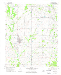
1974 Map of Ringling
USGS Topo · Published 1977About this map
Ringling anchors the landscape of southern Oklahoma in the mid-1970s, positioned along the tracks of the Atchison Topeka and Santa Fe railroad. The settlement pattern here reflects the region's deep ties to the petroleum industry, dominated by the expansive Hewitt Oil Field that stretches across the eastern half of the map. Numerous Oil Wells and a complex network of pipelines illustrate the industrial character of the Jefferson and Carter county line. To the south of the main town site, the proximity of Cornish and its associated Cornish Cem and IOOF Cem suggests the historical layers of earlier communities that preceded or were absorbed by the growth of Ringling. The drainage of North Mud Creek and its various branches like Long Brunch provide the primary topographic relief in an area otherwise defined by oil derricks and the Healdton corporate boundary.
Find a feature on this map
23 named features on this map. Tap any name to fly to it.
Don’t see what you’re looking for? This feature index may not catch every label — zoom into the map to look around manually.
Map Details
Editions of this 1974 Ringling Map
This is the sole edition of this map. No revisions or reprints were ever made.
Other maps of this area

1901 · Addington
USGS Topo · 1:125,000

1901 · Ardmore
USGS Topo · 1:125,000

1918 · Ardmore
USGS Topo · 1:125,000

1957 · Ardmore
USGS Topo · 1:250,000

1963 · Ardmore
USGS Topo · 1:250,000

1969 · Healdton
USGS Topo · 1:24,000
1969 · Healdton SW
USGS Topo · 1:24,000
1969 · Fox
USGS Topo · 1:24,000
1974 · Orr
USGS Topo · 1:24,000

1974 · Ringling NW
USGS Topo · 1:24,000