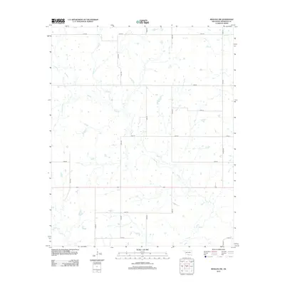
2012 Map of Ringling NW
USGS Topo · Published 2012About this map
Mud Cr and its various tributaries define the drainage patterns of this rural landscape in Jefferson County. The terrain is characterized by a high density of small ponds and catchment areas, suggesting an environment focused on ranching and water management for livestock. The survey reveals a structured grid of rural routes including E1910 Rd and N2970 Rd, which provide access to the dispersed farmsteads and property holdings typical of southern Oklahoma. Notable named waterways such as Negro Cr and Crooked Cr wind through the section lines, while subtle infrastructure like Rapier Blvd and E Pine St appearing on the eastern edge indicates the proximity to more established settlement centers. This map captures the essential rural character of the region, documenting the vital intersections of local roads and creek beds.
Find a feature on this map
19 named features on this map. Tap any name to fly to it.
Don’t see what you’re looking for? This feature index may not catch every label — zoom into the map to look around manually.
Map Details
Editions of this 2012 Ringling NW Map
This is the sole edition of this map. No revisions or reprints were ever made.
Other maps of this area

1901 · Addington
USGS Topo · 1:125,000

1957 · Ardmore
USGS Topo · 1:250,000

1962 · Ryan
USGS Topo · 1:62,500

1963 · Ardmore
USGS Topo · 1:250,000

1964 · Comanche SE
USGS Topo · 1:24,000
1974 · Orr
USGS Topo · 1:24,000

1974 · Ringling NW
USGS Topo · 1:24,000

1974 · Loco
USGS Topo · 1:24,000
1974 · Cottonwood Creek
USGS Topo · 1:24,000
1974 · Ringling
USGS Topo · 1:24,000