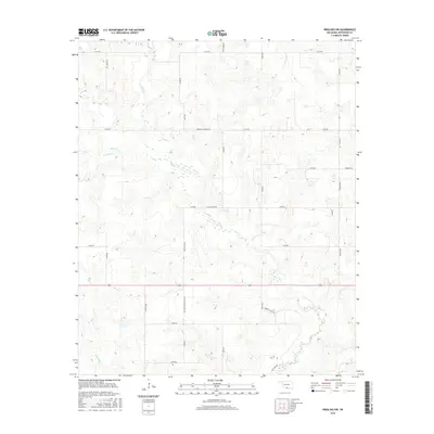
2016 Map of Ringling NW
USGS Topo · Published 2016About this map
Negro Cr and Mud Cr wind through the sectioned plains of Northwest Ringling in this 2016 survey of Jefferson County. The landscape is defined by a dense grid of named rural routes and ranch roads, reflecting modern land management and cattle ranching in the Oklahoma cross timbers. Major corridors such as Mountain Home Blvd and Dillard Tripp Wilson Rd provide access to the interior acreage, while Murphy Ranch Rd highlights the local importance of specific landholdings. In the southern reaches, Post Oak Cr and Crooked Cr continue the intricate drainage pattern typical of the Red River basin. The map illustrates a contemporary rural environment where long-established family names and ranching operations, such as those along Ted Tripp Blvd and J R Ogle Blvd, maintain the continuity of the local community.
Find a feature on this map
29 named features on this map. Tap any name to fly to it.
Don’t see what you’re looking for? This feature index may not catch every label — zoom into the map to look around manually.
Map Details
Editions of this 2016 Ringling NW Map
This is the sole edition of this map. No revisions or reprints were ever made.
Other maps of this area

1901 · Addington
USGS Topo · 1:125,000

1957 · Ardmore
USGS Topo · 1:250,000

1962 · Ryan
USGS Topo · 1:62,500

1963 · Ardmore
USGS Topo · 1:250,000

1964 · Comanche SE
USGS Topo · 1:24,000
1974 · Orr
USGS Topo · 1:24,000

1974 · Ringling NW
USGS Topo · 1:24,000

1974 · Loco
USGS Topo · 1:24,000
1974 · Cottonwood Creek
USGS Topo · 1:24,000
1974 · Ringling
USGS Topo · 1:24,000