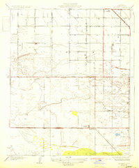
1931 Map of Rio Bravo
USGS Topo · Published 1931About this map
The community of Shafter and the settlement at Rio Bravo occupy a landscape rapidly transforming through infrastructure and industrial development in the late 1920s. A grid of named thoroughfares including Scaroni Avenue and Magnolia Avenue organizes the territory, reflecting the planned expansion of agricultural and utility corridors across the Central Valley. Central to the region's economy is the Southern Pacific railroad, which parallels the Mc Kittrick Bakersfield Highway and supports local facilities like the Oil Pumping Station.
Find a feature on this map
20 named features on this map. Tap any name to fly to it.
Don’t see what you’re looking for? This feature index may not catch every label — zoom into the map to look around manually.
Map Details
Editions of this 1931 Rio Bravo Map
3 editions found
Other maps of this area

1910 · Buena Vista Lake
USGS Topo · 1:125,000

1912 · Buena Vista Lake
USGS Topo · 1:125,000

1929 · Stevens
USGS Topo · 1:31,680

1929 · Coles Levee
USGS Topo · 1:31,680

1930 · Leonards
USGS Topo · 1:31,680

1930 · Wasco
USGS Topo · 1:31,680

1930 · Famoso
USGS Topo · 1:31,680

1930 · Rosedale
USGS Topo · 1:31,680

1931 · Rio Bravo
USGS Topo · 1:31,680

1932 · East Elk Hills
USGS Topo · 1:31,680