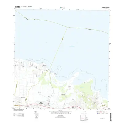
2013 Map of Rio Grande
USGS Topo · Published 2013About this map
Río Grande and its surrounding coastal settlements are documented in this 2013 survey, illustrating the interface between the urban corridor and the Atlantic Ocean. The landscape is defined by the winding course of the Río Espíritu Santo and its tributaries, such as Quebrada Juan González, which flow toward the shore at Boca Herrera. The development pattern reflects a mix of residential centers like Loíza and Vieques alongside established recreation sites including the Berwind Country Club and Rio Mar Club. Further inland, the terrain rises toward peaks like Cerro Bravo and Cerro El Faro, providing a clear view of the transition from the alluvial coastal plains to the higher elevations of the Island of Puerto Rico. This edition captures the established infrastructure of primary routes PR-3 and PR-187 as they connect the coastal communities.
Find a feature on this map
36 named features on this map. Tap any name to fly to it.
Don’t see what you’re looking for? This feature index may not catch every label — zoom into the map to look around manually.
Map Details
Editions of this 2013 Rio Grande Map
This is the sole edition of this map. No revisions or reprints were ever made.
Other maps of this area

1940 · Carolina
USGS Topo · 1:30,000

1941 · Rio Grande
USGS Topo · 1:30,000

1941 · Carolina
USGS Topo · 1:30,000

1945 · El Yunque
USGS Topo · 1:30,000

1946 · El Yunque
USGS Topo · 1:30,000

1946 · Gurabo
USGS Topo · 1:30,000

1946 · Fajardo
USGS Topo · 1:30,000

1947 · Carolina
USGS Topo · 1:30,000

1947 · El Yunque NE
USGS Topo · 1:10,000

1947 · Gurabo NE
USGS Topo · 1:10,000