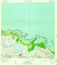
1956 Map of Rio Grande
USGS Topo · Published 1958About this map
Poblado Honduras sits along the northern coastline of this mid-century Puerto Rican landscape, where the Atlantic Ocean meets a series of prominent points including Pta Iglesia and Pta Uvero. The map reveals a structured agricultural and social organization, dominated by several named colonias such as Colonia Mini Mini, Colonia Blasina, and Colonia Carmelita. These settlements are interspersed with essential community institutions like the Escuela Luis Calderon and the Capilla de Nuestra Senora del Perpetuo Socorro.
Find a feature on this map
48 named features on this map. Tap any name to fly to it.
Don’t see what you’re looking for? This feature index may not catch every label — zoom into the map to look around manually.
Map Details
Editions of this 1956 Rio Grande Map
This is the sole edition of this map. No revisions or reprints were ever made.
Other maps of this area

1940 · Carolina
USGS Topo · 1:30,000

1941 · Rio Grande
USGS Topo · 1:30,000

1941 · Carolina
USGS Topo · 1:30,000

1945 · El Yunque
USGS Topo · 1:30,000

1946 · El Yunque
USGS Topo · 1:30,000

1946 · Gurabo
USGS Topo · 1:30,000

1946 · Fajardo
USGS Topo · 1:30,000

1947 · Carolina
USGS Topo · 1:30,000

1947 · El Yunque NE
USGS Topo · 1:10,000

1947 · Gurabo NE
USGS Topo · 1:10,000