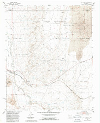
1952 Map of Rio Puerco
USGS Topo · Published 1987About this map
The Rio Puerco riverbed and its surrounding flood control systems dominate this mid-century New Mexican landscape. Extensive land grants define the geography, including the San Clemente Grant and the Isleta Indian Reservation, illustrating the complex historical property divisions of the region. Transportation and infrastructure are concentrated along the river valley, where the Atchison Topeka and Santa Fe railroad line runs parallel to the water's course. A protective Levee and a Gaging Station indicate the critical role of water management in this arid environment. To the south, Hidden Mountain rises as a prominent landmark near the boundary of the Nicolas Duran de Chavez Grant, while the high Mesa to the north overlooks the Gutierrez and Sedillo Grant and the Antonio Sedillo Grant.
Find a feature on this map
15 named features on this map. Tap any name to fly to it.
Don’t see what you’re looking for? This feature index may not catch every label — zoom into the map to look around manually.
Map Details
Editions of this 1952 Rio Puerco Map
2 editions found
Other maps of this area

1917 · Cerro Verde
USGS Topo · 1:125,000

1952 · Wind Mesa
USGS Topo · 1:24,000

1952 · Dalies
USGS Topo · 1:24,000

1952 · Belen
USGS Topo · 1:24,000

1952 · Belen NW
USGS Topo · 1:24,000

1952 · Rio Puerco
USGS Topo · 1:24,000

1952 · Dalies NW
USGS Topo · 1:24,000

1954 · South Garcia
USGS Topo · 1:24,000

1954 · South Garcia SE
USGS Topo · 1:24,000

1954 · Socorro
USGS Topo · 1:250,000