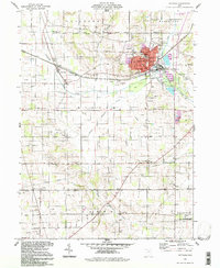
1994 Map of Rittman
USGS Topo · Published 1997About this map
Rittman anchors the landscape where Medina and Wayne Counties meet, sitting at a junction of hydrology and industry defined by Chippewa Creek and the Styx River. The town's industrial character is marked by numerous Salt Wells and a Sewage Disposal plant near the creek banks, while the surrounding rural townships of Guilford, Milton, and Baughman maintain a denser network of local heritage sites. Genealogists will find a high concentration of burial grounds including Shinersburg Cem, St Ann Cem, and Flickinger Cem. To the south, the Johnson Woods State Nature Preserve provides a pocket of preserved timberland amidst the agricultural grid. This survey also records various religious landmarks like The Church on 94 and the Morning Star Ch, alongside the small rail-aligned settlement of Sterling.
Find a feature on this map
50 named features on this map. Tap any name to fly to it.
Don’t see what you’re looking for? This feature index may not catch every label — zoom into the map to look around manually.
Map Details
Editions of this 1994 Rittman Map
This is the sole edition of this map. No revisions or reprints were ever made.
Other maps of this area

1901 · Massillon
USGS Topo · 1:62,500

1901 · Wooster
USGS Topo · 1:62,500

1903 · Massillon
USGS Topo · 1:62,500

1903 · Wooster
USGS Topo · 1:62,500

1903 · Akron
USGS Topo · 1:62,500

1904 · Medina
USGS Topo · 1:62,500

1905 · Akron
USGS Topo · 1:62,500

1906 · Medina
USGS Topo · 1:62,500

1950 · Cleveland
USGS Topo · 1:250,000

1951 · Canton
USGS Topo · 1:250,000