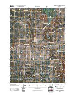
2011 Map of Riverbed Butte Spring
USGS Topo · Published 2011About this map
The Sycan River meanders through the southern reaches of the Sycan Marsh in this remote section of Klamath County. The landscape is defined by its complex network of seasonal water sources and forest management infrastructure, including Thicket Spring and Watkins Spring located near the eastern margins. The transition from the marshland to the forested terrain of Bob Flat is marked by a grid of named forest roads. The naming conventions for local routes, such as Bull Pine Rd, Black Pine Ln, and Red Fir Rd, reflect the dominant timber species of the region. This 2011 survey illustrates the modern configuration of Forest Service access, anchored by the Nat For Dev Rd 46 and the namesake Riverbed Butte Spring.
Find a feature on this map
24 named features on this map. Tap any name to fly to it.
Don’t see what you’re looking for? This feature index may not catch every label — zoom into the map to look around manually.
Map Details
Editions of this 2011 Riverbed Butte Spring Map
This is the sole edition of this map. No revisions or reprints were ever made.
Other maps of this area

1889 · Klamath
USGS Topo · 1:250,000

1894 · Klamath
USGS Topo · 1:250,000

1955 · Klamath Falls
USGS Topo · 1:250,000

1958 · Klamath Falls
USGS Topo · 1:250,000

1960 · Riverbed Butte
USGS Topo · 1:62,500

1960 · Sycan Marsh
USGS Topo · 1:62,500

1960 · Fuego Mountain
USGS Topo · 1:62,500

1960 · Yamsay Mountain
USGS Topo · 1:62,500

1980 · Williamson River
USGS Topo · 1:100,000
1988 · Sycan Marsh West
USGS Topo · 1:24,000