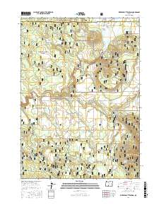
2017 Map of Riverbed Butte Spring
USGS Topo · Published 2017About this map
Sycan Marsh dominates the northern reaches of this high-desert landscape where the Sycan River meanders through the Klamath Basin. This survey records a transition between the Fremont National Forest and Winema National Forest, a region defined by complex forestry management and water conservation. The map reveals an intricate network of service roads named for the timber they access, including White Oak Ln, Shasta Fir Ln, and Black Pine Ln. Local infrastructure is anchored by the Black Hills Guard Station, while essential water sources like Marsh Reservoir, Thicket Spring, and Riverbed Butte Spring are meticulously documented. This data provides a detailed look at the hydrology and land division of the Klamath and Lake County border prior to modern forest service revisions.
Find a feature on this map
33 named features on this map. Tap any name to fly to it.
Don’t see what you’re looking for? This feature index may not catch every label — zoom into the map to look around manually.
Map Details
Editions of this 2017 Riverbed Butte Spring Map
This is the sole edition of this map. No revisions or reprints were ever made.
Other maps of this area

1889 · Klamath
USGS Topo · 1:250,000

1894 · Klamath
USGS Topo · 1:250,000

1955 · Klamath Falls
USGS Topo · 1:250,000

1958 · Klamath Falls
USGS Topo · 1:250,000

1960 · Riverbed Butte
USGS Topo · 1:62,500

1960 · Sycan Marsh
USGS Topo · 1:62,500

1960 · Fuego Mountain
USGS Topo · 1:62,500

1960 · Yamsay Mountain
USGS Topo · 1:62,500

1980 · Williamson River
USGS Topo · 1:100,000
1988 · Sycan Marsh West
USGS Topo · 1:24,000