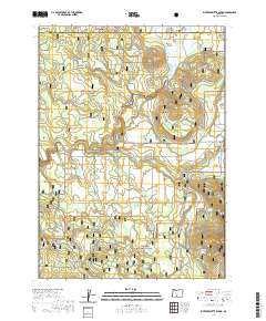
2020 Map of Riverbed Butte Spring
USGS Topo · Published 2020About this map
The Sycan Wild and Scenic River winds through a high-altitude drainage where the Winema National Forest and Fremont National Forest meet. This 2020 landscape is defined by its complex hydrology, dominated by the expansive Sycan Marsh in the northeast and the Marsh Reservoir upstream. The map details a network of vital water sources for forest management and local ecology, including Black Hills Guard Station Spring and Riverbed Butte Spring. Evidence of human use and administrative history is visible through the East-West road corridor and the boundary between Lake and Klamath counties. Topographical features like Bob Flat and various named seeps such as Pelland Spr and Thicket Spring illustrate a territory where seasonal water flow and protected forest lands dictate the layout of the land.
Find a feature on this map
22 named features on this map. Tap any name to fly to it.
Don’t see what you’re looking for? This feature index may not catch every label — zoom into the map to look around manually.
Map Details
Editions of this 2020 Riverbed Butte Spring Map
This is the sole edition of this map. No revisions or reprints were ever made.
Other maps of this area

1889 · Klamath
USGS Topo · 1:250,000

1894 · Klamath
USGS Topo · 1:250,000

1955 · Klamath Falls
USGS Topo · 1:250,000

1958 · Klamath Falls
USGS Topo · 1:250,000

1960 · Riverbed Butte
USGS Topo · 1:62,500

1960 · Sycan Marsh
USGS Topo · 1:62,500

1960 · Fuego Mountain
USGS Topo · 1:62,500

1960 · Yamsay Mountain
USGS Topo · 1:62,500

1980 · Williamson River
USGS Topo · 1:100,000
1988 · Sycan Marsh West
USGS Topo · 1:24,000