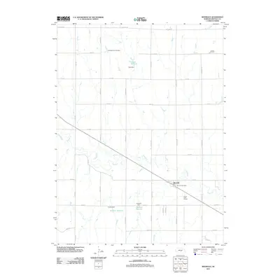
2011 Map of Riverdale
USGS Topo · Published 2011About this map
The Wood River meanders diagonally across this Nebraska landscape, defining the agricultural character of Buffalo County. At the intersection of the river and major regional transit lies Riverdale, the primary settlement on this sheet. The village serves as a central hub for the surrounding township, anchored by the Riverdale Post Office. To the southeast, the Onion Crest Airpark provides a specialized landing point amidst the grid of section roads and farmsteads. The land is heavily shaped by water management, featuring a series of family-named water works including Hadwiger Reservoir, Jacobson Reservoir, and Eisele Reservoir. These features, along with the Lutheran Cemetery in the northeast, reflect a landscape deeply tied to German-American settlement patterns and the essential need for irrigation in the Platte River valley watershed. A strict grid of named routes like Sartoria Rd and Eagle Rd organizes the terrain into the productive agricultural blocks characteristic of the Great Plains.
Find a feature on this map
36 named features on this map. Tap any name to fly to it.
Don’t see what you’re looking for? This feature index may not catch every label — zoom into the map to look around manually.
Map Details
Editions of this 2011 Riverdale Map
This is the sole edition of this map. No revisions or reprints were ever made.
Other maps of this area

1894 · Kearney
USGS Topo · 1:62,500

1896 · Kearney
USGS Topo · 1:125,000

1955 · Grand Island
USGS Topo · 1:250,000

1957 · Grand Island
USGS Topo · 1:250,000

1958 · Grand Island
USGS Topo · 1:250,000

1961 · Amherst
USGS Topo · 1:24,000

1962 · Riverdale
USGS Topo · 1:24,000

1962 · Elm Creek East
USGS Topo · 1:24,000
1962 · Miller NE
USGS Topo · 1:24,000
1962 · Pleasanton NW
USGS Topo · 1:24,000