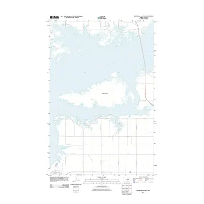
2011 Map of Riverdale North
USGS Topo · Published 2011About this map
Lake Sakakawea dominates this North Dakota landscape, its expansive waters surrounding the significant landmass of Mallard Island. This 2011 survey captures a shoreline defined by intricate inlets and wetlands, reflecting the modern management of the Missouri River reservoir system. To the north, Custer Mine Pond Rd hints at the region's industrial history, while the southern portion of the map reveals a structured grid of rural roads and residential streets like Missouri Dr and Minnesota Ave. The drainage patterns of the prairie are visible through the winding course of Aggie Brown Coulee, which cuts through the agricultural sections south of the lake. This map serves as a detailed record of the intersection between the massive scale of the lake and the local road networks that serve the surrounding McLean County communities.
Find a feature on this map
18 named features on this map. Tap any name to fly to it.
Don’t see what you’re looking for? This feature index may not catch every label — zoom into the map to look around manually.
Map Details
Editions of this 2011 Riverdale North Map
This is the sole edition of this map. No revisions or reprints were ever made.
Other maps of this area

1922 · Garrison
USGS Topo · 1:62,500

1929 · Coleharbor
USGS Topo · 1:62,500

1948 · Stanton
USGS Topo · 1:62,500

1949 · Stanton
USGS Topo · 1:62,500

1949 · Washburn
USGS Topo · 1:62,500

1954 · McClusky
USGS Topo · 1:250,000

1958 · McClusky
USGS Topo · 1:250,000

1961 · Underwood
USGS Topo · 1:24,000
1969 · Garrison Dam South
USGS Topo · 1:24,000
1972 · Garrison Dam North
USGS Topo · 1:24,000