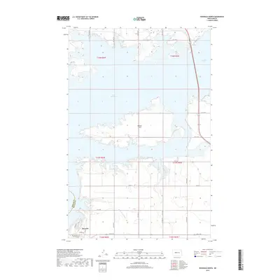
2018 Map of Riverdale North
USGS Topo · Published 2018About this map
Lake Sakakawea dominates this 2018 survey, its expansive waters shaping the geography of Mercer and McLean Counties near the Garrison Dam vicinity. The settlement of Riverdale occupies the southwestern corner, characterized by residential street patterns such as Missouri Dr and 7th St NW perched above the drainage of Angie Brown Coulee. North of the town, the massive peninsula of Mallard Island extends into the lake, while to the northeast, the waters of Audubon Lake are visible along the corridor of State Highway 83. The map details the modern landscape of this Missouri River reservoir area, illustrating the transition from open prairie to managed waterways and agricultural section lines like Co Rd 15 and 14th St NW.
Find a feature on this map
21 named features on this map. Tap any name to fly to it.
Don’t see what you’re looking for? This feature index may not catch every label — zoom into the map to look around manually.
Map Details
Editions of this 2018 Riverdale North Map
This is the sole edition of this map. No revisions or reprints were ever made.
Other maps of this area

1922 · Garrison
USGS Topo · 1:62,500

1929 · Coleharbor
USGS Topo · 1:62,500

1948 · Stanton
USGS Topo · 1:62,500

1949 · Stanton
USGS Topo · 1:62,500

1949 · Washburn
USGS Topo · 1:62,500

1954 · McClusky
USGS Topo · 1:250,000

1958 · McClusky
USGS Topo · 1:250,000

1961 · Underwood
USGS Topo · 1:24,000
1969 · Garrison Dam South
USGS Topo · 1:24,000
1972 · Garrison Dam North
USGS Topo · 1:24,000