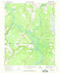
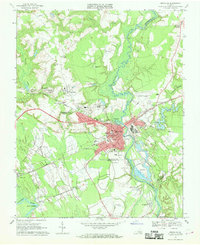
1967 Map of Riverdale
USGS Topo · Published 1986About this map
Chowan River and its major tributaries, the Nottoway River and Blackwater River, define this landscape along the border of Virginia and North Carolina in the mid-1960s. The confluence of these waterways created a network of landings and wharves essential for regional commerce, including Cobbs Wharf, Macks Wharf, and Gatlington Landing. The terrain is characterized by intricate waterways like Simms Gut and Round Gut, as well as broad stretches of land such as Maneys Neck and Reynoldson. Settlement patterns are concentrated around local crossroads and river points, with Riverdale and Riddicksville serving as local hubs. The presence of Diamond Grove Ch and Mt Olive Ch highlights the community structure in this agricultural and timber-producing region. Transportation is facilitated by the Seaboard Coast Line railroad and several bridges, notably the General Vaughan Bridge and Monroe Bridge.
Find a feature on this map
46 named features on this map. Tap any name to fly to it.
Don’t see what you’re looking for? This feature index may not catch every label — zoom into the map to look around manually.
Map Details
Editions of this 1967 Riverdale Map
3 editions found
Other maps of this area

1908 · Winton
USGS Topo · 1:62,500

1919 · Boykins
USGS Topo · 1:48,000

1920 · Holland
USGS Topo · 1:62,500

1920 · Boykins
USGS Topo · 1:62,500

1943 · Holland
USGS Topo · 1:62,500

1953 · Norfolk
USGS Topo · 1:250,000

1957 · Holland
USGS Topo · 1:62,500

1966 · Sunbeam
USGS Topo · 1:24,000
1967 · Courtland
USGS Topo · 1:24,000
1967 · Franklin
USGS Topo · 1:24,000