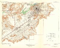
1942 Map of Riverside and Vicinity
USGS Topo · Published 1942About this map
The citrus-growing heart of Riverside is documented here at the end of the 1930s, showing a landscape defined by expansive irrigation and transit networks. Irrigation features like Mockingbird Res and the Santa Ana River supported the region's agricultural economy, anchored by the Univ. of California Citrus Experiment Sta. The map highlights a concentration of institutional history, including the Sherman Institute and La Sierra College, alongside public infrastructure such as the County Farm and County Hospital. Residential growth is evident in the grid of Riverside and outlying communities like Arlington and Casa Blanca. Transportation is a central theme, with the Union Pacific and Pacific Electric lines threading through the valley between the Pedley Hills and the Box Springs Mountains, connecting local industry to the broader Southern California market via thoroughfares like Magnolia Ave.
Find a feature on this map
47 named features on this map. Tap any name to fly to it.
Don’t see what you’re looking for? This feature index may not catch every label — zoom into the map to look around manually.
Map Details
Editions of this 1942 Riverside and Vicinity Map
2 editions found
Other maps of this area

1896 · San Bernardino
USGS Topo · 1:62,500

1897 · Cucamonga
USGS Topo · 1:62,500

1898 · San Bernardino
USGS Topo · 1:62,500

1900 · Cucamonga
USGS Topo · 1:62,500

1901 · Southern California Sheet No. 1
USGS Topo · 1:250,000

1901 · San Bernardino
USGS Topo · 1:62,500

1901 · Elsinore
USGS Topo · 1:125,000

1901 · Riverside
USGS Topo · 1:62,500

1902 · Corona
USGS Topo · 1:125,000

1903 · Cucamonga
USGS Topo · 1:62,500