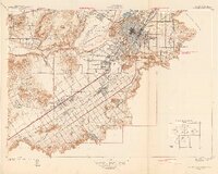
1942 Map of Riverside and Vicinity
USGS Topo · Published 1942About this map
The citrus groves and growing residential street grids of Riverside dominate this landscape just as the local economy was transitioning during the early 1940s. The map captures the significant rail infrastructure that once defined the region, showing the convergence of the Union Pacific, Southern Pacific, and Atchison Topeka and Santa Fe lines, along with the Pacific Electric route. Prominent institutional landmarks such as the Sherman Institute, La Sierra College, and the Univ of California Citrus Experiment Sta highlight the city's role as a regional center for education and agricultural research.
Find a feature on this map
63 named features on this map. Tap any name to fly to it.
Don’t see what you’re looking for? This feature index may not catch every label — zoom into the map to look around manually.
Map Details
Editions of this 1942 Riverside and Vicinity Map
2 editions found
Other maps of this area

1896 · San Bernardino
USGS Topo · 1:62,500

1897 · Cucamonga
USGS Topo · 1:62,500

1898 · San Bernardino
USGS Topo · 1:62,500

1900 · Cucamonga
USGS Topo · 1:62,500

1901 · Southern California Sheet No. 1
USGS Topo · 1:250,000

1901 · San Bernardino
USGS Topo · 1:62,500

1901 · Elsinore
USGS Topo · 1:125,000

1901 · Riverside
USGS Topo · 1:62,500

1902 · Corona
USGS Topo · 1:125,000

1903 · Cucamonga
USGS Topo · 1:62,500