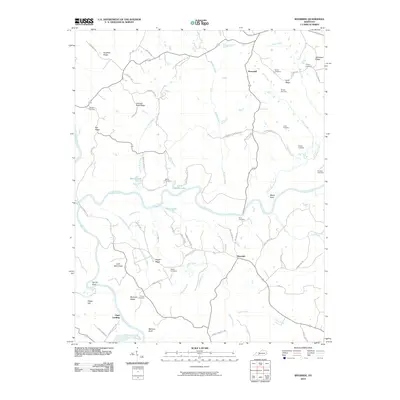
2010 Map of Riverside
USGS Topo · Published 2010About this map
The Green River and Barren River converge in this section of Warren County, defining a landscape of sharp ridges and winding waterways. Small settlements and historic river points like Riverside and Clark Landing are connected by a network of rural roads such as Richardsville Rd and Old Cedar Grove School Rd, reflecting the area's agricultural and river-based heritage. This 2010 USGS survey is particularly valuable for genealogists, as it identifies numerous family burial grounds including Peyton Cemetery, Johnson Cemetery, and Nudger Cemetery. Elevation varies from the bottomlands near Sproul Bend to prominent high points like Little Barn Knob and Flippo Hill. Along the tributaries, several small bodies of water such as Martin Lake and Upton Lake dot the terrain, while landmarks like Lettered Rock Ridge and Pisgah Ridge provide distinct navigational markers across the countryside.
Find a feature on this map
76 named features on this map. Tap any name to fly to it.
Don’t see what you’re looking for? This feature index may not catch every label — zoom into the map to look around manually.
Map Details
Editions of this 2010 Riverside Map
This is the sole edition of this map. No revisions or reprints were ever made.
Other maps of this area

1914 · Little Muddy
USGS Topo · 1:62,500

1922 · Leitchfield
USGS Topo · 1:48,000

1922 · Brownsville
USGS Topo · 1:62,500

1923 · Brownsville
USGS Topo · 1:62,500

1925 · Spring Lick
USGS Topo · 1:62,500

1925 · Leitchfield
USGS Topo · 1:62,500

1953 · Ready
USGS Topo · 1:24,000

1954 · Evansville
USGS Topo · 1:250,000

1954 · Bowling Green North
USGS Topo · 1:24,000

1954 · Welchs Creek
USGS Topo · 1:24,000