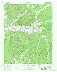
1951 Map of Riverside
USGS Topo · Published 1971About this map
The Buffalo River snakes through the center of this Tennessee landscape, defining the character of the Riverside and Providence area. This map documents a transitional period in the mid-20th century where the traditional river-valley settlement pattern, marked by local family cemeteries like Banks Cem and Dabbs Cem, coexisted with active industrial extraction. A heavy concentration of Strip mines is visible on the ridges south of Providence, particularly along Wye Hollow and Peery Branch. The topography is defined by the sharp transition from the flat Texas Bottoms to the high ground of Waynesboro Ridge and Buttermilk Ridge. Local social centers such as Grinders Creek Ch and the settlement of Ruppertown provide critical anchors for genealogists tracing family roots in Lewis and Lawrence counties.
Find a feature on this map
99 named features on this map. Tap any name to fly to it.
Don’t see what you’re looking for? This feature index may not catch every label — zoom into the map to look around manually.
Map Details
Editions of this 1951 Riverside Map
3 editions found
Other maps of this area

1901 · Colombia
USGS Topo · 1:125,000

1905 · Waynesboro
USGS Topo · 1:125,000

1936 · Riverside
USGS Topo · 1:24,000

1936 · Graves Spring
USGS Topo · 1:24,000

1936 · Deerfield
USGS Topo · 1:24,000

1936 · Henryville
USGS Topo · 1:24,000

1936 · Negro Hollow
USGS Topo · 1:24,000

1936 · Kimmins
USGS Topo · 1:24,000

1936 · Topsy
USGS Topo · 1:24,000

1936 · Gordonsburg
USGS Topo · 1:24,000