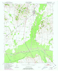
1950 Map of Rives
USGS Topo · Published 1981About this map
The Illinois Central Gulf railroad serves as a central spine through this West Tennessee landscape, anchoring the community of Rives and several smaller agricultural rail stops. This 1950 survey, which received photorevisions in 1980, documents a region defined by its complex bottomland hydrology. The confluence of the North Fork Obion River and the Rutherford Fork Obion River creates a broad, marshy basin characterized by oxbow features like Horseshoe Lake and Long Lake. Much of this wetland area is protected within the Gooch Wildlife Management Area, showing the importance of the river forks to local geography.
Find a feature on this map
26 named features on this map. Tap any name to fly to it.
Don’t see what you’re looking for? This feature index may not catch every label — zoom into the map to look around manually.
Map Details
Editions of this 1950 Rives Map
2 editions found
Other maps of this area

1950 · Obion
USGS Topo · 1:24,000

1950 · Rives
USGS Topo · 1:24,000

1951 · Obion
USGS Topo · 1:24,000

1951 · Rives
USGS Topo · 1:24,000

1954 · Rutherford
USGS Topo · 1:24,000

1954 · Union City
USGS Topo · 1:24,000

1956 · Gardner
USGS Topo · 1:24,000

1956 · Harris
USGS Topo · 1:24,000

1956 · Dyersburg
USGS Topo · 1:250,000
1965 · Kenton
USGS Topo · 1:24,000