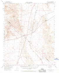
1955 Map of Roach Lake
USGS Topo · Published 1969About this map
Roach Lake and Ivanpah Lake dominate the arid floor of this high-desert landscape along the Nevada-California border. The rugged Spring Mountains and Clark Mtn Range bracket the basins, where the Union Pacific railroad corridor serves as the primary artery for local activity. The map records several small rail-adjacent settlements including Roach, Calada, and Desert, which supported the region's transport and transit needs in the mid-1950s.
Find a feature on this map
24 named features on this map. Tap any name to fly to it.
Don’t see what you’re looking for? This feature index may not catch every label — zoom into the map to look around manually.
Map Details
Editions of this 1955 Roach Lake Map
4 editions found
Other maps of this area

1910 · Ivanpah
USGS Topo · 1:250,000

1912 · Ivanpah
USGS Topo · 1:250,000

1942 · Ivanpah
USGS Topo · 1:250,000

1947 · Kingman
USGS Topo · 1:250,000

1948 · Kingman
USGS Topo · 1:250,000

1954 · Kingman
USGS Topo · 1:250,000

1955 · Kingman
USGS Topo · 1:250,000

1955 · Mescal Range
USGS Topo · 1:62,500

1955 · Roach Lake
USGS Topo · 1:62,500

1956 · Ivanpah
USGS Topo · 1:62,500