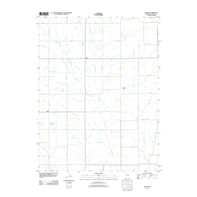
2012 Map of Roads
USGS Topo · Published 2012About this map
The settlement of Roads sits at a crossroads in north-central Carroll County, where the agricultural landscape is defined by a dense network of drainage branches and small prairie lakes. This 2012 survey reveals a rural territory where water management is central to the land use, featuring named bodies such as Amery Lake, Null Lake, and Tweedie Farms Lake. The terrain is dissected by numerous waterways including Turkey Creek, Burr Oak Creek, and Wakenda Creek, which flow through the section lines of the regional county road grid. Further south, the hamlet of Judd marks another small concentration of activity near Judd Branch. This map is particularly useful for those tracking family land in this portion of Missouri, as it documents the locations of private aviation infrastructure like Hawkins Airport alongside the intricate web of county roads that have connected these farmsteads for generations.
Find a feature on this map
37 named features on this map. Tap any name to fly to it.
Don’t see what you’re looking for? This feature index may not catch every label — zoom into the map to look around manually.
Map Details
Editions of this 2012 Roads Map
This is the sole edition of this map. No revisions or reprints were ever made.
Other maps of this area

1889 · Lexington
USGS Topo · 1:125,000

1924 · Dawn
USGS Topo · 1:62,500

1924 · Braymer
USGS Topo · 1:62,500

1950 · Coloma
USGS Topo · 1:24,000

1950 · Plymouth
USGS Topo · 1:24,000

1951 · Utica
USGS Topo · 1:62,500

1953 · Moberly
USGS Topo · 1:250,000

1954 · Moberly
USGS Topo · 1:250,000
1956 · Carrollton West
USGS Topo · 1:24,000

1957 · Moberly
USGS Topo · 1:250,000