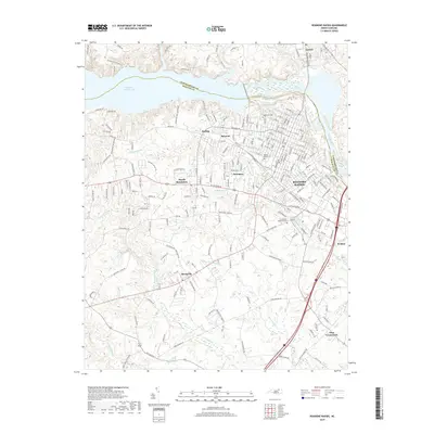
2019 Map of Roanoke Rapids
USGS Topo · Published 2019About this map
Roanoke Rapids and the neighboring industrial hub of Weldon anchor this 2019 survey of the Roanoke River corridor. The landscape is defined by its water management, featuring the expansive Roanoke Rapids Lake and smaller impoundments like Lake Williams and Weights Pond. This modern topographic study reveals the dense residential and commercial expansion in Rosemary and South Rosemary, contrasted with the rural character found toward Days Crossroads and Rheasville. Genealogical researchers can pinpoint several local burial grounds, including Cedarwood Cem, Poplar Grove Cem, and Crestview Memorial Cem. The map provides a detailed view of the infrastructure supporting these communities, from the grid-like streets of the city centers to the winding creeks like Chockoyotte Cr and Quankey Cr that cut through the surrounding wooded terrain.
Find a feature on this map
205 named features on this map. Tap any name to fly to it.
Don’t see what you’re looking for? This feature index may not catch every label — zoom into the map to look around manually.
Map Details
Editions of this 2019 Roanoke Rapids Map
This is the sole edition of this map. No revisions or reprints were ever made.
Other maps of this area

1919 · White Plains
USGS Topo · 1:48,000

1919 · Emporia
USGS Topo · 1:62,500

1920 · White Plains
USGS Topo · 1:62,500

1942 · Emporia
USGS Topo · 1:62,500

1953 · Norfolk
USGS Topo · 1:250,000

1963 · Skippers
USGS Topo · 1:24,000

1963 · Barley
USGS Topo · 1:24,000

1963 · Valentines
USGS Topo · 1:24,000

1973 · Aurelian Springs
USGS Topo · 1:24,000
1973 · Thelma
USGS Topo · 1:24,000