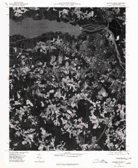
1975 Map of Roanoke Rapids
USGS Topo · Published 1979About this map
Roanoke Rapids Lake and the Roanoke River dominate this orthophotographic study, showing the industrial and residential footprint of the Roanoke Valley in the mid-1970s. The dense urban grid of Roanoke Rapids is visible in sharp detail, revealing the proximity of its neighborhoods to the water's edge and the surrounding agricultural clearings. The map documents the relationship between the river and the established settlements of Weldon and Gaston, where the transit infrastructure and land-use patterns of the era are clearly etched into the landscape. Further south, the rural character of Rheasville provides a contrast to the industrial centers along the river. This aerial perspective captures the exact state of North Carolina's northern borderlands during a period of established textile manufacturing and river-based power generation.
Find a feature on this map
6 named features on this map. Tap any name to fly to it.
Don’t see what you’re looking for? This feature index may not catch every label — zoom into the map to look around manually.
Map Details
Editions of this 1975 Roanoke Rapids Map
This is the sole edition of this map. No revisions or reprints were ever made.
Other maps of this area

1919 · White Plains
USGS Topo · 1:48,000

1919 · Emporia
USGS Topo · 1:62,500

1920 · White Plains
USGS Topo · 1:62,500

1942 · Emporia
USGS Topo · 1:62,500

1953 · Norfolk
USGS Topo · 1:250,000

1963 · Skippers
USGS Topo · 1:24,000

1963 · Barley
USGS Topo · 1:24,000

1963 · Valentines
USGS Topo · 1:24,000

1973 · Aurelian Springs
USGS Topo · 1:24,000
1973 · Thelma
USGS Topo · 1:24,000