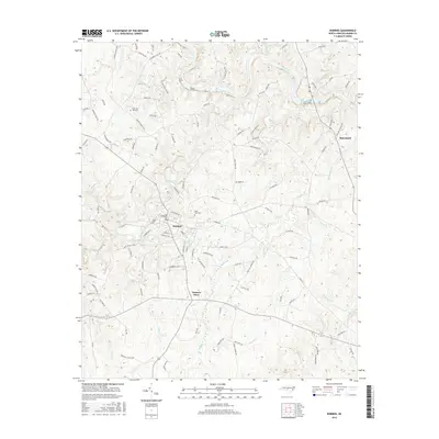
2016 Map of Robbins
USGS Topo · Published 2016About this map
The town of Robbins sits at a geographic crossroads in Moore County, where the dendritic drainage patterns of Bear Creek and Cabin Creek converge. This 2016 survey highlights a landscape defined by its rural settlements and traditional community landmarks, such as New Zion and the crossroads at Garners Store. The topography is heavily influenced by the winding course of the Deep River in the northern section, which is fed by numerous tributaries including Cedar Cr and Falls Cr. Local family history and genealogy are anchored by established sites like New Zion Hill Cem and Pine Rest Cem. The road network, including historic routes like Cedar Hill Rd and Sessoms Rd, reveals the enduring spatial organization of this Piedmont region, connecting scattered homesteads and small hamlets like McConnell to the central hub of Robbins.
Find a feature on this map
112 named features on this map. Tap any name to fly to it.
Don’t see what you’re looking for? This feature index may not catch every label — zoom into the map to look around manually.
Map Details
Editions of this 2016 Robbins Map
This is the sole edition of this map. No revisions or reprints were ever made.
Other maps of this area

1942 · Troy
USGS Topo · 1:125,000

1953 · Raleigh
USGS Topo · 1:250,000

1954 · Raleigh
USGS Topo · 1:250,000

1968 · Erect
USGS Topo · 1:24,000

1968 · Bennett
USGS Topo · 1:24,000

1970 · Bear Creek
USGS Topo · 1:24,000
1974 · Carthage
USGS Topo · 1:24,000

1974 · Putnam
USGS Topo · 1:24,000

1974 · Candor
USGS Topo · 1:24,000
1977 · Robbins
USGS Topo · 1:24,000