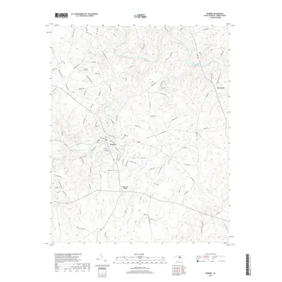
2019 Map of Robbins
USGS Topo · Published 2019About this map
The town of Robbins serves as the central hub for this portion of northern Moore County, where the landscape is defined by the winding course of the Deep River and its numerous tributaries. Settled patterns of the modern era are visible along the road networks radiating from the town center toward smaller communities like Garners Store and McConnell. The terrain is characterized by a dense drainage system including Bear Creek, Buffalo Cr, and Cabin Creek, reflecting the local hydrology that has historically influenced the placement of farms and early homesteads. Genealogists and local historians can find specific points of interest such as the New Zion Hill Cem and Pine Rest Cem, while the extensive list of rural routes like Reynolds Mill Rd and Syrna Church Rd helps preserve the identity of family-owned lands and old milling sites along the creeks.
Find a feature on this map
114 named features on this map. Tap any name to fly to it.
Don’t see what you’re looking for? This feature index may not catch every label — zoom into the map to look around manually.
Map Details
Editions of this 2019 Robbins Map
This is the sole edition of this map. No revisions or reprints were ever made.
Other maps of this area

1942 · Troy
USGS Topo · 1:125,000

1953 · Raleigh
USGS Topo · 1:250,000

1954 · Raleigh
USGS Topo · 1:250,000

1968 · Erect
USGS Topo · 1:24,000

1968 · Bennett
USGS Topo · 1:24,000

1970 · Bear Creek
USGS Topo · 1:24,000
1974 · Carthage
USGS Topo · 1:24,000

1974 · Putnam
USGS Topo · 1:24,000

1974 · Candor
USGS Topo · 1:24,000
1977 · Robbins
USGS Topo · 1:24,000